COG

From Nighttime Lights to Interactive Web Maps: An End-to-End Geospatial Pipeline featured image

From Nighttime Lights to Interactive Web Maps: An End-to-End Geospatial Pipeline

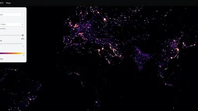
Introduction Nighttime lights data is one of the most powerful proxies for human activity, economic development, and infrastructure growth. Datasets derived from satellite sensors …

GoalSpatial COGServer featured image

GoalSpatial COGServer

GoalSpatial COGServer is a cloud-based COG server for serving large COGs as tiles. This project is maintained by the GoalSpatial team.